Begun on the evening of the 26th of April 2015, in Lang Son. . .but will have to be continued after we see what happens tomorrow. This first real day of the House Hunting expedition, as I've begun to think of it, came in two parts. The first part, getting away from Halong City, into the worst (I think) of the coal mining zone starting just south of Cam Pha and continuing 60 km or so until you're well past the new mega coal burning electric power generating facility at latitude 21° 4'29.90"N and longitude 107°20'52.21"E. Plug those into Google Earth and have a look. . .it's too big to see all at once from the road. It's been generating almost a year now and it takes coal by sea, by rail and by truck, around the clock. A lot of the power seems to run on pylons straight north, where the only customer is the small city of Mong Cai. . .and China. Anyway, it's been a coal dusty sort of road with too much trafffic in the area for years, so this is nothing new, just more of the same. . .but riding through the area this morning I found myself wondering. . .if this is what I do for fun, what would they do to me for punishment. It was basically a scene of paradise turned to Hell. The traffic was fierce, the road was dusty, with little black williwaws of drifting coal dust swirling along behind every vehicle. . .great clouds of it behind the trucks. Fortunately, the coal trucks have their own roads running down out of the mountains to the "coal preparing" factories and the power plant. Unfortunately, those roads cross our roads and the coal trucks have a major priority. . .so the lights turn red for us to let the convoy of coal trucks get through and the traffic on the highway snarls a little worse. If the the road was coal dusty, then so of course was the air. I kept my visor down and was thankful for the mat of gray beard that closes off the bottom of my helmet. . .it's really not a bad air filter, though it gets pretty warm in there waiting for the coal truck parade to finish so we can get moving again. I didn't stop to take any photos. . .ugly country, the mountains all sculpted into coal tailings and haul roads, filthy air, unfit to breathe, an overcast somewhere above the dust that you couldn't see, gray sky, gray land, heavy gray traffic on a gray road with a shimmer of black dust wherever anything moved. . .showing you photos like that would be like showing you photos of my lady love with her hair, face and clothes wrecked and a scowl on her face, if such a thing ever happened. It's just not a done thing!
And then you pass the big generating plant and climb a little hill, the road narrows a bit, traffic drops off to nothing but you, me and the few big trucks running all the way to Nanning in China and you run along with mangrove swamps (muddy at low tide) on your right and to the left, little rounded hills planted to some sort of broad leaf tree that might be rubber, though I'm not sure. . .and finally you come to the mouth of QL4b just before Tien Yen. You simply turn off QLl8 and suddenly it's just lovely country. The sun peeks through the overcast here and there, the mountains turn bright green, where there's level ground that will flood there's bright green new rice growing, and where the fields won't flood there's maize well along, already shoulder high on a man. And of course, where there are fields there are farm houses, and so I went from slow in the coal dust and traffic to slower among the farm houses and fine fields and fair mountains. And that's all there is to report. I got waved at now and then, some kids shouted HELLO, a very nursing mother dog ran across the road in front of me, swaying as she ran and I didn't hit her, the weather got pretty warm, the sun shone through occasional breaks in the clouds, it didn't rain and I stopped a lot to take photos. I did discover what may be the first problem with the whole "taking photos of farmhouses" program, which is supposed to include interior shots of the more interesting homes if possible. The problem may turn out to be. . .farm dogs. Some of them are clearly telling me "Hey You. . .don't come any closer or I'll bark some more and run away again and bark some more and maybe I'll have to bite you. . ." Others don't seem so uncertain. They have a clear cut mission statement that involves eating me alive. H'mm This may pose a problem for the production and photo team. Anyway, it was a lovely run once we turned the corner. I wouldn't wish the first part of the morning on much of anyone though.
And then there was the second day, the 27th of April, from Lang Son to Cao Bang (a big city, almost in China) in time for a late lunch, then on another 44 km into Nguyen Binh, a small town, that is to say, a very small town, further up in the hills, and also almost in China, but without a nearby border crossing gate.
I was up and around reasonably early in Lang Son, paid way way too much for two coffees in the shop down the street from the hotel. . .they saw me coming I guess. . .but had a lovely bowl of chicken noodle soup. This is not your Jewish Mother's chicken noodles. . .not with fish sauce, mint, basil, lettuce and red chiles. . .but it's a good way to start the day. So, fed and watered and paid up at the hotel, we were on the road early. It was a remarkably easy day for navigation. Credit goes to the carefully coordinated use of both the paper map (okay, it's plastic) and the telephone, combined with some judicious advice from the young gentleman who served me lunch and got me firmly started out the right one (of six) exits from the roundabout outside the rice bowl place. I think the phone would have managed without the other two this time, it was right on the money all day (how DO they do that??) but the view from the ground was pretty vague, and really, the phone only works if you know what to ask it! So you really do need the plastic map too. Anyway, we did not get lost and it was basically a marvelous day in the mountains. This is most definitely in the mountains. There was only one long hard climb for the bike, but at least three long and surprisingly steep descents, from which I figure we must have gradually climbed a long ways at least twice in order to come to these drop offs. My ears popped several times during the day. I'll show you a photo or two and you'll see. ..they were mountains. We had hair pin turns and sweepers, and sometimes some really nice road to ride them on and other times not so much so. I got to thinking at one point, staggering from one side of the road to the other, dodging chuckholes, there must be an engineering formula to figure out how much chuck holes slow down each class of traffic. . .I mean, the old Freightliners and Macks from California (Mejia Brothers Trucking?? California plates still on the bumper??) they slam through and hardly slow down it seems, but we motorbikes and the Camrys and small buses can't do it. I'll bet it's a surprisingly small number. Somewhere around 1% of the road surface I'd bet. . .1% of the road surface in chuck holes and ordinary traffic slows to a crawl. . .who knows. But it's a real effect. You'd be better off at that point with a gravel road and a road grader to patrol it, but once it's paved that's probably not happening.
But the worst of the road wasn't any great distance, 20 or 30 km I suppose. Mostly it was just perfectly nice riding, especially later in the afternoon. The last 45 km into Nguyen Binh, after we left the China and Hanoi traffic in Cao Bang, was all but pristine mountain road, smooth fine asphalt, and wide enough for both of us. Normally in this country when you are riding a good road surface you are simply waiting for the inevitable. . .it'll go all to heck. The only question is whether or not you'll see the drop off coming in time to slow down for the first big pot hole. Ths afternoon it didn't happen. We rode right to the hotel in the center of town on fine road. It's worth writing home about!
And speaking of riding, there was an exceedingly rare event today. . .I ran past what must have been a motorcycle travel club from. . .who knows where. . .going the other way! There were at least ten bikes, all very similar, big, heavy road cruisers, definitely not Vietnamese bikes or Vietnamese people. They were all correctly dressed in proper motorcycle gear and had tinted visors on their full face helmets, though enough were open visors that I could see they were fairly tanned Asian people, including several wives or girlfriends riding 2-up. . .and the bikes were all really well equipped with good luggage and chrome, not re-worked military canvas stuff like mine. No matter, we knew who we were and we all waved and one of them gave me a pumped fist. Wow. That's a first!
Back to business. . .we were looking for houses and we had houses in plenty. . .I mean, of course there were lots of houses, the place is full of farmers and charcoal burners and otherwise employed country people, but there is variety! We aren't into the countryside where the houses have great big shaggy roofs with smoke coming out of the thatch, and there aren't that many up on stilts yet, but there are some interesting house styles here and interesting ways of siting them on the land (though mostly it's obvious. . .farm the level ground if there is any. . .and stick the house on the side hill somehow.
H'mm. I suddenly realized I need to get out and find some supper before they roll up the street here (yup, one street, this is Nguyen Binh, and if you can find it on a map you have a map that's good enough to tell the weeds from the flowers. It's a small town. I'll be back.
(time passes. . .it gets really dark, there aren't any street lights here and a lot of front doors are closed for the night. . .more time passes, you begin to get worried. . .then finally, somebody opens the computer. . .it's him, he's back.)
That was close. Aside from the cook eating the left overs I was the last man in the last rice bowl place in town, and they rolled up the street behind me as I walked back to the hotel. Let's look through some photos:
On second thought, let's not! That was five minutes grinding gears and nothing uploaded. I'll get this up tonight as it is and we'll add photos from the next big town I suppose. Nguyen Binh must have a very small cell tower. We DO have internet access. . .but apparently we don't have much band width, or is it filament diameter?
 |
| Here's the fairly wide scale map again with the run through the 27th, having left Halong City (Bai-Chai--Hon Gai and run north to QL 4B (QL = "National Road" I think), thence West and North to Lang Son, where we over-nighted and then on to Nguyen Binh, just 44 km past the big and confusing city of Cao Bang. Cao Bang probably wouldn't have been so confusing but it's undergoing some new road construction that will eventually be a bypass I think. Anyway, I did it wrong and just decided to keep going when I found the door to the right little road onward. |
So, I finally got some photos uploaded here in Ha Giang City. It's late in the evening of the 29th, we've had a couple of fabulous days and while these were loading I was pecking away at a report. It's not ready for publication yet, but maybe in the morning.
 |
| Mountains, complete with farm houses. I'm on topic and doing well thank you. The mountains are limestone where I saw any outcroppings. The soil varies from a buff to a red brown to a pretty definitely red soil, though not the rich red you occasionally find in this part of the world. Oddly enough, the adobe and rammed earth walls of some of the houssw reflect the variation. |
 |
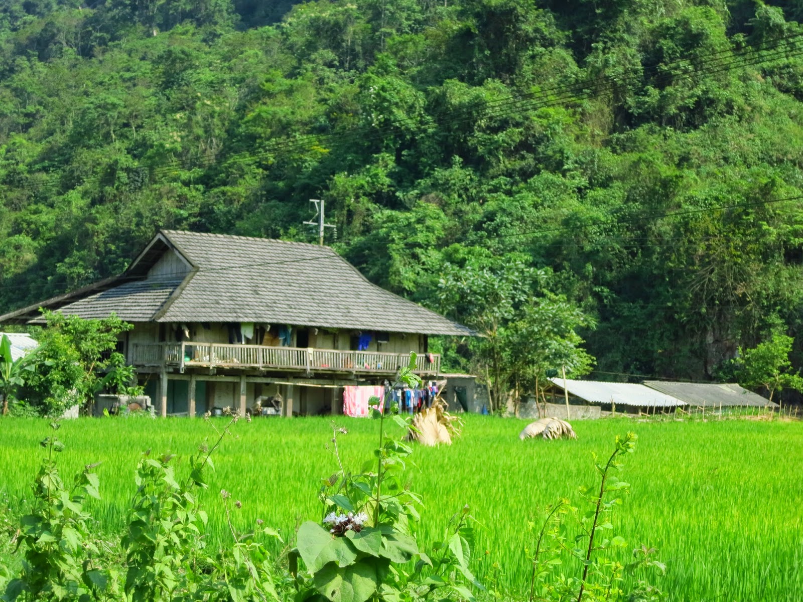
| This is your standard issue Vietnamese house in the country, post 1990 generally, sometimes reinforced concrete structure with brick or concrete block infill, and sometimes simple un-reinforced stacked masonry, plastered and painted (at least on one face). There are thousands of them everywhere, some bigger, some smaller, some with their roofs going the other way, all the variations you can imagine for a simple rectangular house. The balustrade above the porch, either right on the edge of the overhang like this one, or back at the break in the two roofs. . .one way or another, seems to be everyone's idea of the right way to do a roof. There are houses without them, but they look odd. This one, with a full suite of out-buildings, is quite a nice establishment. . .reading from left to right, we have the machinery and motorbike lean to, the main house, with sleeping rooms and for sure the family altar and the hardwood couch and coffee table (sunflower seed and tea table?). Meals are likely eaten on a mat spread out for the purpose on the floor. The plain gray building is probably kitchen and general working space, then the livestock under the open roof, with the pig houses down low where they are easy to wash out and catch the manure. But it's not the "traditional" house I'm wanting to hunt down. |
 |
| This is a timber frame home, "up on stilts", with its columns running from ground level to just below the roof lines, joined by beams mortised into the columns. There seem to be a number of minor variations but they are all basically the same notion, cut the mortises in the columns (on the ground where it's easy) and likewise the tenons on the beams. Erect it, true it up, slide some stone or concrete column bases (pier blocks?) under each column (they seem to just sit there) and then fill in floor on small joists and walls any which way. This one has planks vertically on the face we are looking at and a plastered lattice of woven bamboo on the gable end walls. The stone work is not a foundation, just a wall for whatever. . .and to carry the stairs. |
 |
| This is the only one I saw like this in this neighborhood, but I've seen them a lot elsewhere, will have my eyes open for them. They're sort of a variant on the timber framed house and if you look around you'll find all the variations, from a little infill between the timbers, to something like this, where the ground floor timberwork has been replaced entirely. Probably reinforced concrete columns and beams with masonry block infill. . .the porch overhang wouldn't work with plain stacked masonry, needs the reinforcing bar. A very nice house. . .I like it! |
 |
| Traditional. Timber framed and tile roofed. Infill. . .to close the walls. . .can be anything or nothing but a curtain. Since you often see the curtain solution on brand new houses, I'd guess it's not a long term solution, sort of like living in a mobile home while you build the house, but maybe better. |
 |
| A substantial frame and a good tile roof. . .bamboo lattice closure on the wall. Airy and almost free. Not bad. |
 |
| This compound is interesting! I'd like to get inside and see how it's laid out, but obviously different functionality for different parts. It's plastered with cement stucco, so likely concrete masonry walls, with or without reinforced concrete structure here and there. It would work as plain masonry and would be in the adobe tradition (I don't know what they call it here, but "adobe" is what it is) |
 |
| I really can't tell, is it adobe block or rammed earth? Both are fairly popular where we are going next week. The roof is corrugated cement board (probably not "asbestos board" any more). The brothers really wanted me to stay and talk. Sigh. |
 |
| So, they're town type houses right on the edge of town and they no doubt are farming this last field along the road, so are they farm houses? Not in the terms I intended to use, but it's kind of a fun photo anyway. The basically flat topped building with a tin roof standing on light pipe columns is really a good idea here, and very common. It provides a waterproof roof, always a good thing, but also a wonderful breezy place to hang laundry or grow herbs and flowers or just hang out. |
 |
| And here are a few to show how much you can do with a tiny park at a fork in the road, a piece of tarp, a bag of whole sticky rice (makes nice clean dirt for dump trucks). . .and a few boxes of bright plastic trucks, loaders, hoppers and some sugar scoops. It was obviously a planned event by somebody for something, and it brought a lot of kids and their parents for the hour or so before sunset. |
 |
| It's a done deal, he's a trucker. |
 |
| You keep adding rice and then it dumps all at once and you can start over. great fun! |
 |
| Some people didn't finish supper before they came I guess. Dad just kept interrupting. Dang. |
 |
This is another favorite-all-over-Viet Nam thing to do at the park. . .paint the Plaster of Paris statues with water colors and let your dad play too. Note that even this gentleman's leg bones are too long for him to get his knees under that durned table. The Vietnamese have been growing but their plastic furniture has not. Time for a Change!
|
All right, it's way late but I finally got these up. I'll try again in the morning and see if we can get up to date before we move on to Lao Cai province.